Qrisq Analytics LLC.
×

Contact form submission status.


Hindcast: Post-Event Analysis

After landfall, know a storm’s impact: wind, surge, and rainfall down to each address.

Accurate post-storm analysis

Once the storm has made landfall, Q-risq Analysis focuses on ensuring information accuracy by overlaying our output data with US government sourced LiDAR ground elevation measurements, for both surge and wind.

This allows the government to respond appropriately, the insurance industry to have accurate data for faster claim services, and a homeowner to have the information they need to file an insurance claim.

E

What is included on our Hindcast Impact Report?

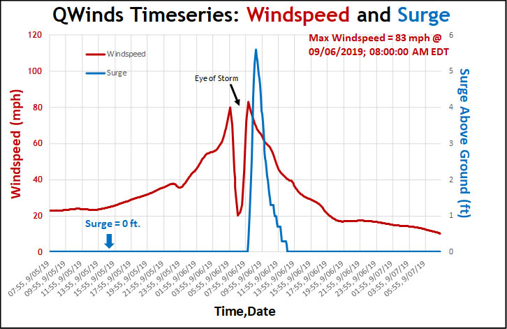
Post-storm analysis for each individual address begins directly after landfall. Wind direction, speed, and duration for each side (NW, NE, SW, SE) of property is detailed on a time series graph, along with above-ground surge levels and cumulative rainfall.

WINDSPEED

Storm surge comes before or after peak winds, depending on if you are east or west of the center point when the storm makes landfall. We can provide max wind speeds and from which direction they came and for how long.

SURGE

We’ve spent years acquiring a one-of-a-kind database using government collected LiDAR data to determine elevation levels above ground, which is key to determine which properties will see storm surge.

Depending upon where a property is located in relation to the storm’s center, the wind and surge time of arrival and their intensities can vary greatly. Our post-storm analysis uses supercomputer processing and over 1,000 water and wind observations to analyze surge levels, maximum wind speed, and direction and duration for each side of the property, giving you the most accurate data.

Who can use our hindcast technology?

HOMEOWNERS

Q-risq Analytics gives homeowners information—whether you are home or not. Our web app is built with homeowners in mind. Q-risq Analytic’s information is specific to each personal address while local weather service broadcasts are generalized for wide areas.

GOVERNMENT

As a hurricane approaches coastal communities, Q-risq Analytics provides necessary information for government and community leaders to consider appropriate measures to safeguard people, equipment, facilities, and supplies.

INSURANCE

Q-Risq’s technology can help you connect with the insured before and after the storm. Find out which PIFs will be affected by winds and surge? What were the hardest hit areas for wind and surge? Send alerts and instructions to mitigate damage. Get a headstart and streamline claims processing after landfall.

Information for every address

When received in advance, each address is geocoded with a precise latitude and longitude, entered into our secure client database, and digitally represented on our map viewer.

Properties can be close to each other but assigned different risk levels; our proprietary Storm Surge and Wind Forecasting Model results are layered over high precision ground elevations. Simply put, properties that sit higher will not be as affected by a given amount of water.

With each National Hurricane Center advisory update, every address is reassessed to determine individual risk based on its forecasted flood depth and maximum wind speed. Ensemble forecasting provides for different storm track scenarios. Once processed against geocoded properties, exposure is assessed, and property owners are alerted to potential dangers.

Our Services

Knowledge is power. Know what to expect before a storm makes landfall; afterward, understand the impact of winds and storm surge with data from Q-risq Analytics.

Track Storm Activity

Stay current on storm activity with the National Hurricane Center’s up-to-date weather information for tropical storms and hurricanes.

Send Us a Message

    Please excuse slower than normal response time during a storm event.